
You're probably doing the same thing most visitors do. You've seen a few photos of emerald alpine lakes, typed Triglavska Jezera zemljevid into search, opened three maps, and somehow feel less certain than when you started.
That's normal. The Triglav Lakes area looks simple on a screen. In reality, it's a proper mountain day, sometimes a long one, and the map only helps if it answers the question: which route suits you, your group, and the conditions on the day you go?
From Bled, I see this planning gap all the time. Families want the least stressful approach. Fit hikers want the best balance of effort and scenery. Solo travellers often want a route that's straightforward to follow without turning the day into an epic return in the dark. The right map isn't just about finding the lakes. It's about choosing the right journey into them.
Table of Contents
- Your Adventure Begins with the Right Map
- Welcome to the Valley of the Seven Lakes
- Choosing Your Triglav Lakes Map
- Popular Routes and Trail Breakdowns
- Trailhead Access and Logistics
- Using GPX Files and Offline Navigation
- Safety First Seasonal and Weather Checks
- Explore the Triglav Lakes with an Expert Guide
Your Adventure Begins with the Right Map
A good map solves stress before it solves navigation.
Hikers don't need another list of pins, huts, and trailheads. They need help deciding whether they should start from Bohinj, whether the day is suitable for children, whether the route is too steep for their knees on descent, and whether the return will still feel manageable after a long climb. That's where a useful Triglavska Jezera zemljevid becomes more than a screenshot.
The map question most hikers are really asking
When someone searches for a Triglav Lakes map, they're usually asking one of these:
- “What's the simplest route?” They want clear markings, a logical trail, and no unpleasant surprises.
- “What's realistic for one day?” They don't want a route that looks short online but feels endless in mountain terrain.
- “Can my group handle it?” That matters more than ambition. A family, a first-time hiker, and a fast solo walker should not choose the same approach by default.
Practical rule: Pick the route first, then the map format that supports it. Don't do it the other way round.
The mistake I see most often is overvaluing the app and undervaluing the route choice. People spend time comparing Komoot, Gaia GPS, OsmAnd, Google Maps, and paper maps, but skip the harder question of effort and timing. In this area, the route choice shapes the whole day. The map is your tool, not your plan.
What a useful map should tell you
For this valley, the best map is the one that helps you judge:
- Entry point
- Trail character
- Approximate time commitment
- Whether the route fits current conditions
- How easy it is to retreat or shorten the day
If a map doesn't help with those decisions, it may still be attractive, but it isn't practical.
Welcome to the Valley of the Seven Lakes
You leave Bled early, the weather looks stable, and the plan sounds simple enough: reach the lakes, have lunch at a hut, and get back before dark. Then the valley starts to stretch. Junctions matter more than expected. The climb feels longer than it looked on a phone screen. That is why this place deserves a clear introduction before you choose your route.
The place behind the search term is Dolina Triglavskih jezer, the Triglav Lakes Valley. It sits high in the Julian Alps between the Bohinj and Trenta sides of the park, and it has long held a special place in Slovenian mountain culture and conservation. If you want broader park context before picking an approach, this Triglav National Park map guide helps you understand how the valley fits into the wider area.
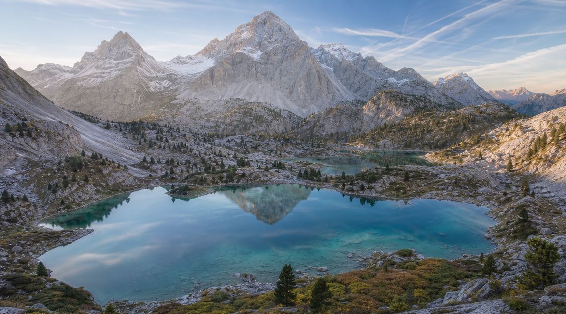
On the ground, this is classic alpine karst. Water disappears, reappears, and shapes the terrain in ways that are beautiful but not always obvious to first-time visitors. You will cross limestone ground, shallow basins, pasture sections, and lake areas that feel close together on a map but take real time to reach on foot.
That matters for decision-making. Families with younger children usually do better with a shorter objective and a clear turnaround point. A fit solo hiker can cover more ground, but still needs to respect how quickly weather and fatigue can change the day. Strong walkers chasing a full valley experience should be honest about ascent, descent, and the return leg, not just the headline destination.
Why people call it the Valley of the Seven Lakes
The name comes from the chain of lakes spread through the valley, with conditions that can look a little different across the season. Some visitors expect one dramatic viewpoint and a quick photo stop. The better mindset is to treat the valley as a journey through several distinct sections, each with its own rhythm, terrain, and effort.
That is also why route choice matters more here than many hikers expect.
A shorter outing can still feel rewarding if your group wants scenery without committing to a very long mountain day. A bigger route makes sense if everyone is experienced, well-paced, and properly equipped. I often tell visitors in Bled the same thing: the best day here is rarely the longest one. It is the one that is appropriate for your group.
The valley rewards respect
The trails are marked and well known, and the huts make the area more approachable than many parts of the Julian Alps. Still, this is high mountain country. Weather shifts fast. Karst ground can be awkward underfoot. A route that looks moderate online can feel demanding by the time you add altitude, breaks, and the descent.
Respect usually looks simple. Start early. Carry more water than you think you need. Keep a spare layer even on a warm day. If someone in the group is fading before the main junctions, shorten the plan early instead of forcing the full route.
That judgment is what turns a famous hike into a good one.
Choosing Your Triglav Lakes Map
Different maps do different jobs. The mistake is expecting one map to do everything well.
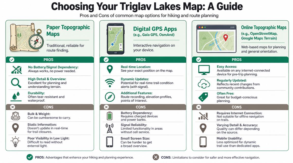
For the Triglav Lakes area, I'd treat your navigation as a small toolkit. Use one map format for planning, another for live navigation, and always keep a non-battery backup if you're heading into the mountains for a full day.
Paper maps still matter
A proper paper topographic map still does one thing better than a phone. It gives you broad terrain awareness at a glance.
That matters in the Julian Alps because route shape, side valleys, huts, contour spacing, and escape options make more sense when you can see the whole area at once. On a small phone screen, hikers often zoom too far in and lose context. Then they understand the next turn, but not the full day.
Paper maps also don't care about battery, cold, or a dropped phone.
What doesn't work so well is convenience. They're slower to use on the move, awkward in wind or rain if not protected, and static by nature.
Web maps are best for planning at home
Web maps are excellent before the trip. They help compare trailheads, measure overall route logic, and check where huts sit in relation to ridges and junctions. For visitors building an itinerary around Bled, Bohinj, or Trenta, that planning view is often enough to avoid a poor route choice before the boots go on.
A good starting point is this broader Triglav National Park map guide, especially if you're still trying to understand how the Triglav Lakes fit into the wider park.
The weakness of web maps is obvious. They assume internet access and a planning mindset. They're less useful once you're already on the trail.
Offline apps work best on the trail
For live movement, phone apps are often the most practical option. Komoot, Gaia GPS, and OsmAnd all help hikers follow location in real time and avoid wrong turns at junctions. That's especially helpful when a tired descent makes even simple decisions feel less obvious.
Still, apps create their own problems:
- Battery dependence can become serious on a long day.
- Small screens make terrain interpretation weaker than on paper.
- Imported tracks aren't the same as judgment. A line on a screen won't tell you if the route is a smart choice for your group.
Use your phone for confirmation, not blind obedience. If the route on screen and the terrain around you don't seem to match, stop and reassess.
My practical mix is simple. Plan on a larger screen, carry a paper backup if the day is substantial, and find your way on the trail with an offline app you already know how to use.
Popular Routes and Trail Breakdowns
You're at breakfast in Bled, the forecast looks decent, and everyone says they want to see the Triglav Lakes. But the question is simpler. Which route gives your group a good mountain day instead of a long, tired retreat?
That choice usually comes down to three things. How much climbing your group handles well, how comfortable everyone is on a full-day trail, and whether you want the shortest sensible access or a longer approach that feels more like a journey.
The clearest benchmark for first-time planning is the standard route from Planina Blato. Hribi lists Planina Blato to Koča pri Triglavskih jezerih at about 3 h 15 min on a marked trail, on Hribi's route page for Planina Blato to Koča pri Triglavskih jezerih. For many hikers, that makes it the most forgiving choice in this area. It is still a proper mountain walk, but the day usually feels more manageable than the bigger climbs from lower starts.
Route choice starts with honest limits
Families, mixed-pace groups, and hikers who enjoy the scenery more than the effort should usually bias toward the route with less total strain. That often means Planina Blato.
Strong solo hikers and experienced pairs have more options, but the trade-off stays the same. A route can be shorter in distance and still feel harder because the ascent is steeper, the surface is rougher, or the return comes after your legs are already fading.
Three common approaches
1. Planina Blato to Koča pri Triglavskih jezerih
This is the route I suggest most often to first-time visitors staying around Bled or Bohinj. It gives you the classic Triglav Lakes experience without spending the first hours of the day fighting the mountain.
Best for: active families with older children, steady walkers, and anyone who wants the safest balance between reward and effort.
Watch for: underestimating the return. People often focus on reaching the hut and forget they still need enough energy to descend well.
2. Koča pri Savici via Komna
This route suits hikers who are comfortable with a longer climb from the start. The challenge is not route-finding on a normal clear day. The challenge is sustained uphill work and the way it wears down slower hikers before they reach the main valley.
The Slovenian Mountaineering Association map portal lists Komna to Koča pri Triglavskih jezerih at 7.49 km and about 2 h 40 min, shown on the maPZS listing for Komna to Koča pri Triglavskih jezerih. That segment alone is enough to keep the day serious. Add the approach to Komna and the route stops being a casual outing.
Best for: fit hikers, mountain regulars, and visitors who already know they are comfortable with a demanding ascent.
Watch for: choosing it because it looks direct on the map. It often feels harder on the body than people expect.
3. Bohinj side via Stara Fužina and the pasture chain
This is the choice for hikers who want the approach itself to be part of the experience. The route builds gradually through the pasture world above Bohinj and feels more immersive than driving higher and starting later.
As noted earlier, this line follows the well-known Bohinj-side progression through the pastures before reaching the valley. It makes sense for hikers with good stamina and enough daylight. It is a poor fit for anyone trying to squeeze the lakes into a rushed schedule.
Best for: hikers who want a longer day with more of the scenery unfolding step by step.
Watch for: starting too late. On a big route, timing mistakes are harder to fix than map mistakes.
| Route | Starting Point | Distance (One Way) | Elevation Gain | Est. Time (One Way) | Best For |
|---|---|---|---|---|---|
| Planina Blato route | Planina Blato | Not cited in the verified data | Not cited in the verified data | About 3 h 15 min | First-timers, steady walkers, families with older children |
| Savica and Komna approach | Koča pri Savici | Not cited in the verified data | 1,280 m | About 5 h | Strong hikers comfortable with a demanding ascent |
| Bohinj pasture approach | Stara Fužina side | Not cited in the verified data | Not cited in the verified data | Longer full-day outing | Hikers who want a longer, more immersive approach |
If you want a Slovene route overview that helps compare how these options feel on foot, this Sedmera Jezera trail guide with route context is a useful companion.
If two routes seem possible, choose the one that leaves some margin for weather, pace, and tired legs. That decision usually gives you the better day.
Trailhead Access and Logistics
A route can look perfect on the map and still go wrong before you start walking. Most delays happen lower down. Parking confusion, wrong road assumptions, or choosing a trailhead that doesn't fit your transport plan can ruin the day.
What works smoothly and what causes delays
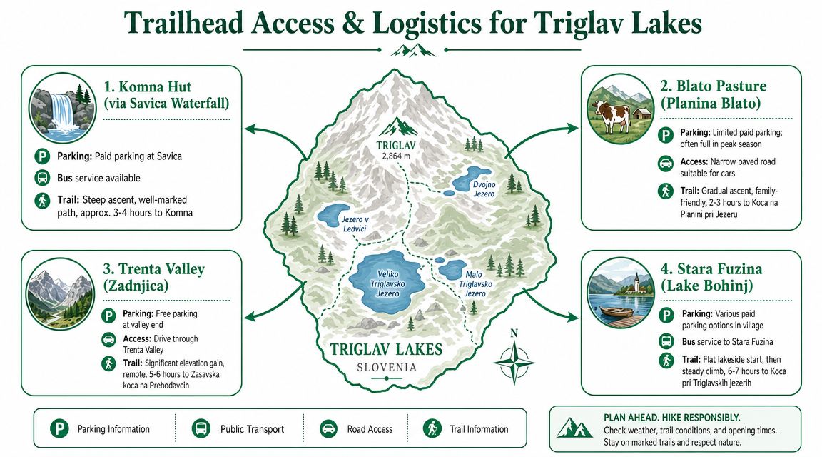
The most practical approach is to decide logistics in this order:
- Choose your trailhead first. Don't start with accommodation location alone. The right start point depends on your route and fitness.
- Check whether you're driving or using public transport. Those are different planning worlds.
- Leave earlier than feels necessary. Popular mountain access points don't get easier later in the day.
For visitors based around Bled and Bohinj, the transport side matters. If you're relying on buses rather than a car, this overview of Bled and Bohinj bus options helps you work out what gets you closest before the hike begins.
Planina Blato is often attractive because it shortens the walking compared with starting lower down. The trade-off is that it's a committed trailhead choice. Savica makes sense for hikers who already know they want the steeper Komna approach. Stara Fužina is more suitable for those building a fuller Bohinj-side day and who don't mind the longer progression.
A useful GPS reference inside the valley
If you want one precise reference point for orientation in the lower valley, use Črno jezero. The SPZ dive map places it at 46.29885°N, 13.79559°E at about 1,300 m elevation on the SPZ Črno jezero map PDF.
That's helpful for GPS orientation, especially if you want to confirm where you are in relation to the lower part of the lake chain. It's also a reminder that this area isn't flat, simple parkland. Even a single lake here sits within a more complex karst setting than many visitors expect.
Using GPX Files and Offline Navigation
A GPX file is just a route file. It shows a recorded or planned track that your app can display on a map. That's all. It isn't magic, and it isn't a substitute for mountain judgment.
Used properly, though, GPX is one of the most helpful tools for the Triglav Lakes area. It reduces hesitation at junctions, confirms that you're still on the intended line, and helps you keep a better sense of progress when trail signs and fatigue start competing for your attention.
What a GPX file is actually for
A GPX track is strongest when it does three jobs:
- Confirms position when you reach a junction and want reassurance
- Supports timing decisions by showing how far you still have to go
- Helps on descent when concentration often drops
It's weakest when hikers treat it like an autopilot. Trails change in feel, weather changes visibility, and a route that's right in summer may not be right in shoulder season. The track itself can't evaluate that for you.
A simple way to use GPX safely
Keep it straightforward.
- Choose one app you already know how to use. Don't test a brand-new navigation app for the first time at the trailhead.
- Import the GPX file before your trip. Check that the line opens correctly in the app.
- Download the full offline map area. Do this on hotel Wi-Fi, not in a mountain car park.
- Mark key points manually. Trailhead, hut, turnaround point, and parking are usually enough.
- Bring backup power. Cold mornings and long screen time drain batteries faster than people expect.
GPX works best when you check it briefly and regularly. It works worst when you ignore the map all day and then panic after a wrong turn.
For this valley, I'd also keep your phone use disciplined. Airplane mode with offline maps loaded is usually a better trail setup than constantly searching for weak signal. It saves battery and reduces distraction.
Safety First Seasonal and Weather Checks
A Triglav Lakes map is not a fixed promise. It's only valid in the context of the season, the weather, and your own skill level.
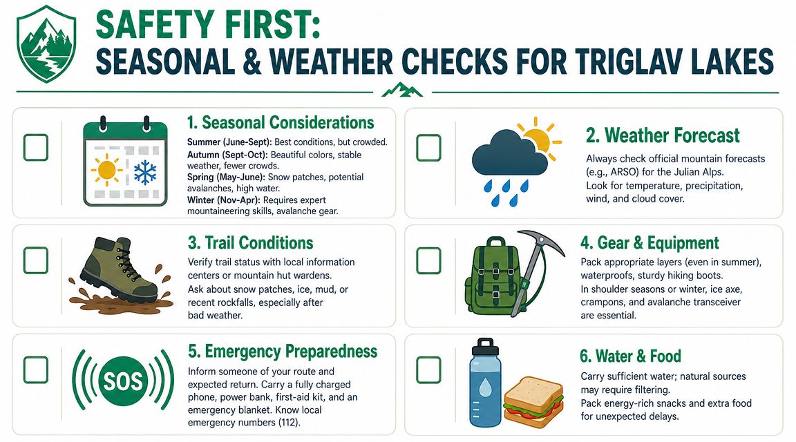
That matters here because many online maps present summer hiking logic as if it applies all year. It doesn't. As noted on the Wikipedia entry for Dolina Triglavskih jezer, access in spring or autumn can be completely different from July, and a route that is straightforward in summer may require alpine equipment and skills when snow is present.
A summer map is not a year-round answer
Hikers often get caught. They search a route in clear weather, save the map, and assume the same line is appropriate a few weeks later.
In the Julian Alps, that assumption can fail quickly. Snow patches, frozen ground, wet limestone, closed huts, shorter daylight, and storm timing all change the meaning of the same route. The line on the map may be identical. The day itself is not.
For travellers who depend on mobile data for forecasts, transport checks, and hut information, having reliable coverage matters. If your home plan is awkward abroad, sorting Slovenia eSIM plans before you arrive can make trip-day checks much easier.
Checks worth doing before you leave Bled or Bohinj
Treat these as indispensable habits, not mere additions:
- Check mountain weather, not valley weather. A pleasant morning by the lake tells you very little about high ground later in the day.
- Confirm hut status. A hut shown on your map may not be open when you expect.
- Read your route in both directions. Many people only plan the climb and forget how tired they'll feel coming back.
- Adjust for your weakest hiker. Group pace always follows the slowest comfortable person.
- Set a turnaround time. If the day runs behind schedule, turn back early rather than negotiating the final hour under pressure.
Conditions decide whether a route is appropriate. Pride doesn't.
Maps are powerful. But in mountain terrain, they only become safe when paired with current judgment.
Explore the Triglav Lakes with an Expert Guide
You reach Bohinj early, the forecast looks decent, everyone feels strong, and then the true questions start. Which trailhead saves the most effort. Is the planned route still right for the slowest person in the group. Do you push higher or keep the day enjoyable. That is the point where a good guide earns their place.
For the Triglav Lakes, guided and self-guided trips can both work. The better choice depends on how much route judgment, timing, transport, and group management you want to handle yourself. I usually suggest DIY for confident hikers who read maps well, start early, and are happy adjusting plans on the spot. I suggest a guide for visitors who want the right route chosen for their actual group, not the route that looked best on a screen the night before.
Why local knowledge changes the day
A guide's value is not just showing the path. It is making dozens of small decisions well.
That matters most when a group is mixed. One person wants a big mountain day, another is nervous on rocky ground, and someone else is fit but has never hiked in alpine terrain. In that situation, the best route is rarely the longest or most famous one. It is the one that fits the group's pace, confidence, and turnaround point.
A strong guide helps with:
- Route choice that matches families, first-time alpine hikers, or stronger walkers who want more distance
- Pace and energy management so the day stays steady from the first climb to the descent
- Trailhead decisions based on weather, season, and how much ascent your group should really take on
- On-the-day adjustments if legs are fading, clouds are building, or the original plan no longer makes sense
- Context on the valley so the lakes, karst ground, huts, and high pasture terrain mean more than names on a map
When guided makes more sense than DIY
A guided day is often the smarter call if your time in Slovenia is short, your group has different fitness levels, or you want to avoid spending half the evening sorting transport and route options. It also makes sense for solo travellers who are comfortable walking but would rather have local judgment on trail choice and timing.
Families benefit in a different way. The right guide will not only shorten the route. They will choose a trail that gives children a good day out without turning the return walk into a long struggle.
If you'd rather explore with the planning, transport, and route decisions already handled, have a look at Outdoor Slovenia Activities. They organise beginner-friendly, well-run outdoor days from the Bled area and can help you choose the right mountain experience for your group.